The Zartico Place-Based Strategy
Zartico’s Destination Operating System™ leverages the highest frequency and highest resolution data available, allowing destinations to see in near real-time the behavioral patterns created by visitors and residents alike as they move throughout and experience a destination.
Zartico’s proprietary place-based strategy is the foundation from which we leverage data to create the insights found within the ZDOS™.
Defining Your Place-Based Strategy
Creating the gold standard in destination data mapping
Your destination is like no other. The unique arrangement of places — parks, restaurants, shops, hotels, businesses, trails, museums, neighborhoods — is as singular as a fingerprint.
Zartico’s Place-Based Strategy uses a tested methodology and expert standards to map your distinctive collection of places. This allows us to integrate four powerful data sets to illuminate trends and deliver actionable insights tailored to your destination’s needs.
Our GIS experts do the heavy lifting
We start by setting boundaries. The geographic boundary — typically a census-designated boundary such as a city, county, or state — contains all of the places that make up your destination.
The boundary is used to determine whether a person actually visited or spent money within the destination. It’s also critical for normalizing the incoming data streams.
From there, we begin filling the boundary with points of interest — or as we call them, places of impact (POIs, for short).
Our GIS team identifies key visitation drivers, and then adds in additional places from our extensive global database. This ensures we’re measuring the impact of the full visitor experience, including the main attraction (like the Grand Canyon) and other places a visitor will stop along the way (like the diner or gas station down the road).
Our expert-driven mapping methodology…
- Eliminates “homework” for destinations — no more lists to make!
- Reduces human bias introduced through handpicking POIs
- Optimizes coverage across several tourism-related categories
- Right-sizes a destination’s POI list relative to its size and population
- Uses industry-specific standards to maximize the accuracy of geolocation observations
Adding layers of understanding
Two more features of your destination map unlock helpful filters for analyzing data within the Zartico Destination Operating System® (ZDOS®).
Regions are groups of places that are related to one another geographically. Destinations can customize regions to fit their needs. Common groupings include neighborhoods, historic districts, TBIDs, or different parts of a state with similar travel patterns and visitor experiences.
Categories sort places by common experience or type — such as restaurants, accommodations, outdoor recreation, or transportation. Analyzing visitor data by category reveals behavioral trends and is the first step to discovering visitor preferences and personas.
We apply the same categories to geolocation data, spending data, event data, and website content — allowing you to layer data sets and explore the intersections of related patterns.
Why it matters
Zartico’s Place-Based Strategy reveals the big-picture impacts of the visitor economy on the places you help market and manage.
Our expert methodology removes human bias and creates industry standards that facilitate meaningful benchmarking. We also apply proprietary data science techniques to filter out hotspots and remove roadways, reducing statistical noise and ensuring the highest possible standard of data quality.
Did we mention onboarding is a breeze? Instead of tedious homework, you get to hit the ground running with insights that answer your strategic questions.
Only Zartico has invested this level of attention, expertise, and learnings from working with 300+ unique destinations. Find out how to tap into the possibilities of your places to move your community forward.
What Standard Place Looks Like In The ZDOS™
Standard Place-Based Geographic Granularity For Your Destination’s Places:
☑️ Region (Partner Defined, Strategically Aligned)
☑️ County
☑️ City
Standard Place-Based Geographic Granularity For Origin Markets:
☑️ Country
☑️ State
☑️ Market Areas (US only)
☑️ County
☑️ City
☑️ Zip Code (coming soon)
Purpose: Because travel is fundamentally tied to a physical place, we’ve added these geographic granularities to the data model, giving more options for layering insights together.
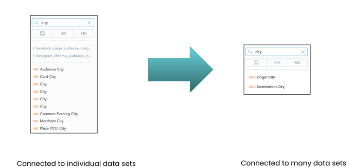
Example: What pops up if you type "City" in the Analyze section...
(Analyze is available to partners on a Standard or Enterprise package level)